top of page

01
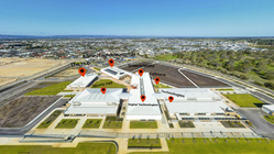
360° Virtual Walkthrough of the interior of properties as well as 360° bird's eye view


02
WE DIGITIZE YOUR PROPERTY
NEW ONLINE VISUALISATION OPPORTUNITIES WITH DRONES, 360 PHOTOGRAPHY, & AI
At Droneify, we specialize in digitizing residential and commercial properties with cutting-edge drone technology. From high-resolution marketing visuals that captivate buyers to detailed aerial inspections that enhance safety and efficiency, our solutions bring properties to life like never before. We also streamline online inductions with immersive aerial mapping, ensuring seamless onboarding for staff and contractors. Whether you need stunning real estate footage, precise site assessments, or virtual walkthroughs, Droneify delivers the clarity and insight you need. Click below to see how our clients use our technology.
03
bottom of page


